Planning a cycling holiday in Wiltshire? Scroll down for a list of bike hire options.
Cycling & Cycle Routes in Wiltshire
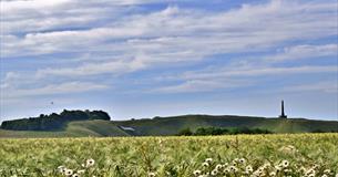
Cycling in Wiltshire's peaceful, timeless countryside will show you rural England at its very best.
The Wiltshire Cycleway threads its way through Wiltshire along quiet country lanes and passes many of the county's most attractive places to visit. The 160 mile cycle route is supplemented by a network of shorter loops offering a wide choice of distance and terrain.
A great off-road cycling route is to follow along the Kennet & Avon Canal tow path. On this route you will pass the Crofton Beam Engines, Caen Hill lock, Pewsey Wharf and the historic towns of Bradford on Avon and Devizes.
Hire a bike or join a cycle tour
Want to get cycling but not sure where to begin? If you are looking to hire a bike, try out Towpath Trail in Bradford on Avon.
Download some of our cycling routes
Cycle maps and routes for various towns including Chippenham, Bradford on Avon, Marlborough, Salisbury and Trowbridge as well as a Salisbury to New Forest cycle map can be downloaded from the Connecting Wiltshire website.
You can also download the following routes:
Cycle Route 1 - Avon Valley Explorer
45 km/ 28 miles 5-6 hours Moderate
Follow the Avon River from the Vale of the White Horse via Stonehenge and Old Sarum to Salisbury Cathedral.
Combine with the Wylye Valley and Salisbury Plain Explorers for a spectacular three-day circular navigation of south Wiltshire.
Cycle Route 2 - Wylye Valley Explorer
33 km/ 20.5 miles 4-5 hours Moderate
From the Cathedral City of Salisbury past the majestic Wilton House, take the back road through the Wylye Valley past some of Wiltshire's finest chalk downland to the market town of Warminster.
Combine with Avon Valley and Salisbury Plain Explorers for a spectacular three-day circular navigation of South Wiltshire.
Cycle Route 3 - Salisbury Plain Explorer
53 km/ 33 miles 6-7 hours Moderate
Cycle the range from Westbury White Horse to the Pewsey Vale.
From tanks to wild orchids, explore this unique cycle route around the Imber and Larkhill military ranges.
Combine with Avon Valley and Wylye Valley Explorers for a spectacular three-day circular navigation of South Wiltshire.
Cycle Route 4 - Woodford Valley Circuit
26 km/ 16 miles 3 hrs 30 mins Moderate
Explore some of Wiltshire's finest villages, delight in the natural beauty of the River Avon and see the ancient archaeology of Old Sarum and Stonehenge.
Cycle Route 5 - Wylye Valley and Grovely Ridge
27 km/ 17 miles 4 hours Moderate OR 15 km/ 9.25 miles
Cycle the quiet, broad avenues of Grovely Wood then descend into the tranquil Wylye Valley for refreshments and an easy ride home.
Two Tunnels Greenway (Bradford on Avon to Bath)
20km/12.5 miles 2.5/3.5 hours
An easy accesible route from Bradford on Avon the Two Tunnels Greenway is not to be missed. Cycling up the towpath from Bradford on Avon you can link onto the route at Conkwell Wood and carry on a long the Kennet & Avon Canal to the Two Tunnels Path. This is where you can experience going through Combe Down Tunnel, at one mile long it is the longest cycling tunnel in Briain!
Listed below are further cycling routes you can enjoy in the Cranborne Chase and West Wiltshire Downs National Landscape:
A ride through the Deverills
Hills and Valleys through Wilton
Choose from the long or short option to suit your time.
Search for cycle friendly places to stay
Many of our accommodation providers offer special facilities for cyclists from secure bike storage through to maps and route suggestions.
Listed below are providers that offer such facilities.
Click on the listings below for further information and to book your cycling break...


 to add an item to your Itinerary basket.